
As the Cultural Value of Coastlines project has concluded, we no longer contribute new posts to this blog. However, you can continue to read our blog posts in this archive.
Dublin Bay: Meet the Experts
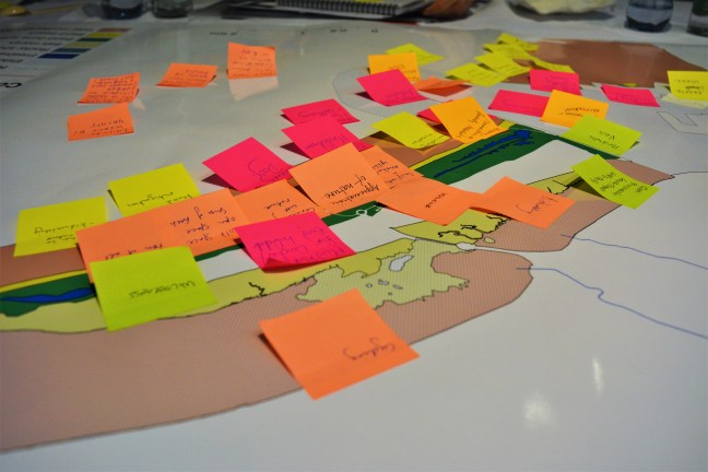
On Thursday 8th February the Cultural Value of Coastlines research project held an advisory meeting at the National Maritime Museum of Ireland. This was an opportunity to bring together some key decision-makers and specialists from the Dublin Bay area to discuss how we might think of the marine environments of the bay as being culturally valued.

The meeting included a presentation of the research so far and think-tank discussions of the key benefits and challenges for Dublin Bay as well as imagining future scenarios for the Bay. The museum provided an opportune backdrop for exploring the many ways that cultures and natures combine at the coastline. The advisers described many cultural benefits arising out of Dublin Bay, such as: connecting with nature, recreation, aesthetic values (including from industrial heritage) and spaces for environmental education.
The next steps for the research will be to meet as many local interest groups as possible to discuss how they interact with Dublin Bay and its ecosystems. If you know of a group or are interested in this research please contact us or explore our website to find out more.

A View of the Bay

The ‘cultural value’ of our project title perhaps gives the impression of something which is fixed and measurable, something which might be determined by counting how many people like or use a particular beach, or by estimating what people would be willing to pay to live on a coast road with a sea view. But cultural value is something which is constantly subject to change, and intimately connected to our sense of identity, place, and belonging. It can be difficult to predict what aspects of our coastline will retain, or acquire, cultural value.
The most prominent example of this in Dublin Bay is the twin chimneys of the Poolbeg electricity generating station. Built in the 1970s, the chimneys rise to just over 680 feet high, and were part of a more ambitious plan which would have seen six chimneys in total built on the site. The oil crisis of 1973 put a brake on the rush to build more oil-fired power stations, however, and so the Dublin skyline was left with what became known at the time as the ‘goalposts’. The height of the chimneys was controversial. Dublin had restricted, and continues to limit, the development of high-rise buildings. This remains a striking feature of the city, especially when viewed from the bay. The chimneys are the tallest structures in the city, and because of their coastal location are especially prominent when Dublin is approached by sea, and indeed by air, as the main runway at Dublin Airport is oriented to route most arriving planes from the east over the sea. As a result, over the almost forty years they were in operation, the red-and-white striped chimneys became visual icons.

When the chimneys were decommissioned by the Electricity Supply Board in 2010, the Dublin City councillor, Dermot Lacey, led a vigorous and widely-supported campaign to save them from demolition. This resulted in a council decision in 2014 to list the chimneys in the Register of Protected Structures. The campaign revealed the extent to which Dubliners had become attached to the chimneys as symbols of their sense of place. Returning migrants talked about the chimneys as the first visual sign that they had arrived home. Architects, designers, and artists began to talk about how the redundant chimneys might be lit up like the Eiffel Tower, or might be made into a tourist attraction. The chimneys began to appear on posters, artworks, t-shirts, bags, postcards, and tea towels (Una Mullally reported on this phenomenon for The Irish Times in this video link).
It is clear when you see the use of the chimneys as a design emblem on such products that this mirrors a pattern in many other cities around the world, except that whereas London has Big Ben, Paris has the Eiffel Tower, New York has the Statue of Liberty, Sydney has the Opera House, and so on, Dublin’s most iconic visual representation is a pair of redundant pieces of industrial infrastructure. Of course, Belfast shares this fetishization of industrial structures – the twin shipyard cranes of Harland and Wolff adorns the same kinds of artwork and merchandise in Belfast – but the shipyards occupied a much more central place in the growth, development, and economic life of Belfast, and the image of the cranes might be understood to encapsulate a way of life. Dublin was never industrial in the same way, and it could be said that Poolbeg power station was only ever central to the life of the city in a visual (and strictly electrical) sense. The chimneys have become iconic not because Dubliners are especially nostalgic for some mythic ‘good old days’ of generating electrical power from burning imported oil, or for a once-glorious industrial past, but because they symbolise the city skyline. They have come to mean ‘home’, and are therefore imbued with cultural value.
The campaign to save the chimneys has also sparked a shift from issues of preservation to questions of aesthetic imagination. How might these once functional pieces of industrial architecture become a cultural amenity? As Maggie Roe argues, there is also a broader issue at stake about the management of ‘sense of place’, and the potential to orient debates about place towards a creative rather than purely preservationist principle:
“Discussion of sense of place related to landscape has tended to centre on how to conserve or preserve existing sense of place, sometimes built up over many years, in highly valued landscapes. There has been little discussion about how we might create landscapes with a sense of place that is highly valued from landscapes that are presently degraded or ordinary.”[i]
This is particularly significant given the location of the chimneys on the Poolbeg peninsula, which was created from the dumping of rubble and rubbish, fuel ash from the power station, and dredged mud from the river, and which, as Richard Nairn, David Jeffrey, and Rob Goodbody observe, has ever been ‘dominated by utilities such as the port, power stations, sewage treatment works and the latest addition, the waste-to-energy plant’.[ii] The popularity of schemes to transform former coastal sites of waste or industry into spaces for cultural recreation, and the support garnered for campaigns such as ‘Save Our Seafront’, indicate a more general trend towards re-valuing our coastline, and even re-imagining how functional and industrial landscapes might be integrated into the cultural life of the city.

Dublin Port is itself emblematic of this trend. Once in the heart of the city, with ships unloading their wares on to the quaysides, the port moved gradually further east, reclaiming land from the sea as it withdrew into its own enclosed peninsula within the bay. There are few reasons to venture into the port area today if you are not a truck driver or a ferry passenger. For security reasons, docksides are fenced off and beyond limits for any passers-by, and it would be difficult to identify anything which might be described as a cultural amenity. Yet the port lies in the geographic centre of the bay, and in a city which appears to be increasingly conscious of the benefits and fragility of coastal habitation, it is a focal point for issues of urban development and environmental and social impact. The reinvention of the former docklands area in the 1990s, in the style of many other urban waterfront regeneration schemes around the world, partly restored a link between the city and the port, although it also kindled an appetite among developers for imagining how the port might make way entirely for expensive waterfront apartments and office blocks.[iii] Dublin Port’s own Masterplan 2012-2040 (which can be found here), meanwhile, envisions some attempts to re-integrate the port into the life of the city, with ‘soft boundaries’, maritime art installations, and walkways and cycleways constructed into and around the port infrastructure. The masterplan represents a shift in thinking about the relationship between the port and the city. The economic and logistical functions of the port remain clearly central, but there is a recognition also of what infrastructural developments might be needed to facilitate leisure and recreation, to serve the needs of boat-watchers and bird-watchers, and to re-invent redundant port equipment and buildings as part of the city’s cultural heritage.
The resurrection of Crane 292 as an architectural monument at the entrance to the port is a symbol of this shift in understanding the importance of the role that seemingly everyday or functional objects play in cultural life.[iv] As John Frow argued in his book on Cultural Studies and Cultural Value, it has long been a truism of cultural studies that ‘no object, no text, no cultural practice has an intrinsic or necessary meaning or value or function; and that meaning, value and function are always the effect of specific (and changing, changeable) social relations and mechanisms of signification’.[v] For this reason, the re-invention of the Poolbeg chimneys and Crane 292 as objects with cultural value deserve our attention for what this indicates about the changing and changeable nature of our relationship with ports, coasts, and seas.

Notes:
[i] Maggie Roe, ‘Making Sense of Place and Landscape Planning at the Landscape Scale’, Making Sense of Place: Multidisciplinary Perspectives, ed. by Ian Convery, Gerard Corsane, and Peter Davis. Woodbridge: Boydell Press, 2012, 191-206 (191).
[ii] Richard Nairn, David Jeffrey, and Rob Goodbody, Dublin Bay: Nature and History. Cork: The Collins Press, 2017, 244.
[iii] Niamh Moore, Dublin Docklands Reinvented: The Post-Industrial Regeneration of a European City Quarter. Dublin: Four Courts Press, 2008.
[iv] http://www.dublinport.ie/news/crane-292-stands-tall-20-years/
[v] John Frow, Cultural Studies and Cultural Value. Oxford: Clarendon Press, 1995, 145.
Beneath an ampler sky
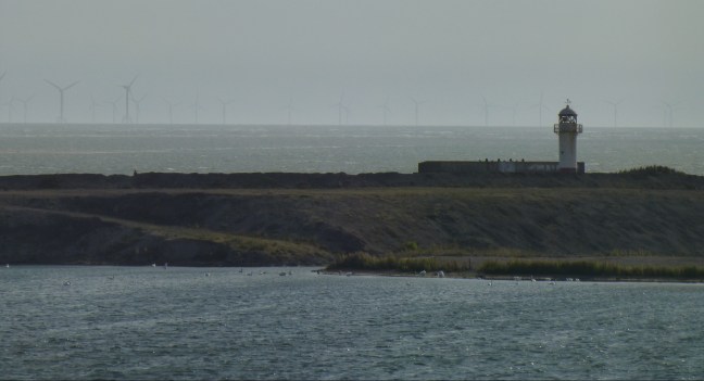
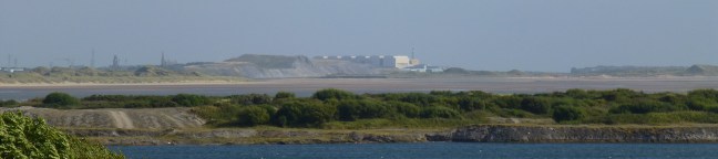
Between the former iron mines at Hodbarrow and the shipbuilding town of Barrow-in-Furness, the river Duddon completes its journey to the sea. Just off the coast lies one of the largest offshore windfarms in Europe, West of Duddon Sands, with 108 wind turbines generating power since their installation in 2014. Along the coastline to the North lies the large nuclear complex of Sellafield, with its ‘toadstool towers’, as the poet, Norman Nicholson, described them.[i] South of the estuary, the great halls of the submarine shipyard at Devonshire Dock in Barrow-in-Furness are visible along the skyline for miles around. The shores of the Duddon estuary and its adjoining coasts have been home to mining and heavy industry throughout the past two centuries. They have never been more than sparsely populated, have never attracted much interest from the tourists who flock to the Lake District, and have never lost a sense of geographical remoteness. A constant theme in local politics, since the beginning of the nineteenth century, has been the desire to bridge or reclaim land from the estuary, and consequently to make its coastal communities and industries more accessible for commercial and tourist traffic. Just as constant has been the history of failed or abandoned schemes to do so.[ii] The railway bridge across the Duddon lies five miles up the estuary; the road bridge a couple of miles further upriver. Crossing Duddon sands was never as difficult or treacherous as crossing Morecambe Bay – both lay along the old West Coast route from Lancaster to Whitehaven – but it did require knowledge of the tides and sands, and, as Nicholson writes, for most travellers before the nineteenth century, the route along these coastal bays, was ‘a nuisance to be endured as patiently as possible’.[iii] J.M.W. Turner passed along this route and sketched the Duddon estuary in 1809, returning later in the 1820s to a turbulent graphite and watercolour depiction of storm-shadowed sands.[iv]

The perceived remoteness of the Duddon estuary, from the perspective of potential tourists, at least, is evident in some of the earliest published guides. Ann Radcliffe’s account of her travels through England (1795) includes a panoramic vision of the Cumbria coast from the summit of Skiddaw: ‘We stood on a pinnacle, commanding the whole dome of the sky. The prospects below, each of which had been before considered separately as a great scene, were now miniature parts of the immense landscape’. The view encompasses the Solway Firth and Scottish mountains to the north, Whitehaven and Cockermouth, and the ‘vast tract of low country, which extends between Bassenthwaite and the Irish Channel’, the Isle of Man as a ‘long blackish line’ to the west, and then, to the south, ‘beyond all the fells of the lakes’, Lancaster sands, and ‘Duddon sands gleamed in a long line among the fells of High Furness’.[v] Radcliffe’s journey takes her southwards through Borrowdale, then to Windermere, Hawkshead, down to Ulverston, and then on to Furness Abbey. The coast was a view framed from the heights of the Fells, with few places along the shoreline worthy of the trouble it took to visit. Stephen Gill argues that this pattern was already entrenched in the most venerated guidebooks of the Lake District, by John Brown (1767), Thomas Gray (1769), Thomas West (1778), William Gilpin (1786), and by Radcliffe (1795), those which set the trend for tourism in the late eighteenth century:
“Following the routes that would include the unmissable sights, while travelling along decent roads served by tolerable inns, they mapped out the essential northern tour – Kendal to Keswick, taking in Windermere, Rydal Falls and Grasmere; from Keswick into sublime Borrowdale; from various directions into Patterdale and Ullswater. Expeditions along the south-western coastal strip might include the ruins of Furness Abbey and Piel Castle. Not one of the guides ventures into the Duddon valley.”[vi]
Even the first guide to encourage his readers along the Duddon valley, William Green, a friend and neighbour of William Wordsworth, begins his journey not at the coast but at Broughton, and offers no description of the estuary until he depicts it through the eyes of his fourteen-year-old daughter, Sarah, when they have walked together to Goats Water tarn near Coniston:
“The last ascent to the lake [Goats Water] is steep and craggy, and turning round after a considerable and uninterrupted exertion, Sarah espied the sands of Duddon, the sea, the Isle of Peel, and all the intervening landscape, on which the sun shone, though with a watery glory; her youthful mind was lost in wonder and astonishment at the scene before her; her hitherto visible horizon being the fells of Ambleside and Keswick, and the flats of Bassenthwaite and Windermere.”[vii]
This uplifting scene of the Duddon estuary conforms to the aesthetic taste for the picturesque which shaped many accounts of touring the Lake District, perhaps most characteristically in its depiction of a wondrous or awe-inspiring view earned as a reward for the exertion of climbing to a great height. The desire which this scene inspires in his daughter, ‘that on the following morning a journey might be made to Broughton and the sands’, however, is thwarted by Green who, ‘having other views’, presumably to press on into the fells and lakes he was sketching, persuades her to abandon the idea.
The framing of the Duddon estuary as a picturesque scene – best viewed from a distance, but not worth visiting – is an important context for Wordsworth’s collection of sonnets, The River Duddon (1820). Wordsworth had been commending his readers to visit the Duddon valley as early as his first collection of poetry, An Evening Walk (1793), in which he wrote in a footnote that ‘Perhaps this poem may fall into the hands of some curious traveller, who may thank me for informing him, that up the Duddon, the river which forms the estuary at Broughton, may be found some of the most romantic scenery of these mountains’.[viii] Wordsworth was conscious from the beginning of his poetic career that in celebrating the virtues of hitherto remote and unknown localities in the Lake District, he was also making a case for tourism to those places. Yet this poetic championing of the local and the rural seemed to hamper his reputation as a poet, with many reviewers expressing the wish that he should not waste his talents on secluded hills and poor farmers. One reviewer of his River Duddon collection lamented that he should choose the Duddon, and not the ‘majestic Thames’.[ix] The poet, Lord Byron, expressed a similar lament in verse, when he wrote of Wordsworth’s celebration of the local: ‘There is a narrowness in such a notion/ Which makes me wish you’d change your lakes for ocean’.[x] Yet Wordsworth’s reputation was cemented by the collection he published in 1820 which not only chose as its title the least well-toured valley of the Lake District, but it also included his Topographical Description of the Country of the Lakes in the North of England. The poet and the tour guide were united in one volume, and the collection marked a transition in how Wordsworth was read. As Fiona Stafford writes, ‘The poems could hardly have been more specifically located, nor the location more obscure and, yet, the reception was surprisingly positive’.[xi] The Lake District had been ever present in his earlier verse, but as Christopher Donaldson argues, from 1820 onwards ‘it became increasingly fashionable to read Wordsworth not just for the sake of the moral principles that his verse contained, but also for the special insights it offered about his local landscape’.[xii] This began in the summer of 1820 with visitors calling at his home on their way through the landscapes he depicted in his poems, and continues to this day in the tourist industry which thrives in the Lake District and which largely depends upon the literary legacy of Wordsworth. Yet the Duddon estuary remains off the beaten track of modern day tourists, and even Wordsworth’s earliest followers rarely ventured beyond the valley to the sands of the Duddon coast.
The reason for this might lie partly in the sonnets themselves, as well as the reputed remoteness of the estuary. Wordsworth traces the Duddon from its source down to the estuary in thirty-three sonnets. Indeed the sequence begins with a note explaining the course of the river: ‘The River Duddon rises upon Wrynose Fell, on the confines of Westmorland, Cumberland, and Lancashire; and, serving as a boundary to the two latter counties, for the space of about twenty-five miles, enters the Irish sea, between the isle of Walney and the Lordship of Millum’.[xiii] As the river reaches Broughton, Wordsworth sets out his vision of the estuary:
“Not hurled precipitous from steep to steep;
Lingering no more ‘mid flower-enamelled lands
And blooming thickets; nor by rocky bands
Held; but in radiant progress toward the Deep
Where mightiest rivers into powerless sleep
Sink, and forget their nature – now expands
Majestic Duddon, over smooth flat sands
Gliding in silence with unfettered sweep!
Beneath an ampler sky a region wide
Is opened round him: – hamlets, towers, and towns,
And blue-topped hills, behold him from afar;
In stately mien to sovereign Thames allied
Spreading his bosom under Kentish downs,
With commerce freighted, or triumphant war.
“But here no cannon thunders to the gale:
Upon the wave no haughty pendants cast
A crimson splendour: lowly is the mast
That rises here, and humbly spread, the sail;
While, less disturbed than in the narrow Vale
Through which with strange vicissitudes he passed,
The Wanderer seeks that receptacle vast
Where all his unambitious functions fail.
And may thy Poet, cloud-born Stream! be free –
The sweets of earth contentedly resigned,
And each tumultuous working left behind
At seemly distance – to advance like Thee;
Prepared, in peace of heart, in calm of mind
And soul, to mingle with Eternity!”[xiv]
As the river slows and widens, leaving behind the drama of its descent through rocks and thickets, the poet is drawn to an expanding vista of the ‘smooth flat sands’, of the ‘radiance’ of the river ‘Beneath an ampler sky’, and the disappearance of the river into the oblivion of the sea. Just as the river has been figured throughout the sonnets as analogous to the poet’s life, here at the estuary, it is figured as entering the ‘powerless sleep’ of death. This is where rivers ‘forget their nature’, or lose their identity, and become connected through the seas to all other rivers and all other lands. Indeed it is at this point that Wordsworth might be said to belie his critics for wishing him to choose greater rivers or oceans as his poetic subject, for in these sonnets he shows the Duddon to be both distinct from, and interconnected to, other places. The moral virtue of the ‘lowly’ and the ‘humble’ is associated with the local, lesser known places of England, and is shown through contrast with the commercial and martial power of the capital. But these sonnets also witness a change in perspective. No place names are given here, unlike the route he has traced down from Wrynose, and through Donnerdale, Seathwaite, and Ulpha. There are no details of the flora and fauna of the riverside along the estuary, and there is no encouragement to the traveller ‘who walks with Duddon for his guide’ to extend his journey beyond Broughton.[xv] The ‘ampler sky’ makes a spectacle of the river’s flow into the sea, but this is a view to behold ‘from afar’, at a ‘seemly distance’. Wordsworth holds the estuary within the realm of the picturesque, in other words, quite separate from his deep attachment to the intimate localities of the lakes and fells inland.
Perhaps Wordsworth set a pattern for later visitors in his distinction between close attention to the land and a distant vista of the estuary. In his 1844 guide, Rambles by Rivers, for example, James Thorne tracked the course of the Duddon using Wordsworth’s sonnet sequence as his guide: ‘he must be dull indeed who could wander without emotion along one [a river] that has been sung of by a great poet; or not have the feeling its natural beauty may arouse deepened by association with the genius it has inspired’.[xvi] As the river descends to the flat lands of the estuary, however, Thorne struggles to find the widening and taming Duddon as attractive as its upper course, and strains against Wordsworth’s comparison of the estuary to the Thames, of which he says ‘it must be confessed it requires all fancy’s help to sustain the resemblance’.[xvii] But the picturesque view of the estuary remains to be cherished:
“Still it is a noble sight, when the full tide has laid the whole stretch of sand, a mile and half across, under water, to gaze from some elevated spot over it as it mingles its waters with the mighty ocean, the setting sun meantime blending all into a glow of golden splendour, while thousands of waterfowl, darting in every direction with the swiftness almost of the lightning, and baffling the keenest eye to follow their rapid evolutions, impart an air of liveliness to a scene that might else perhaps be too sombre from its uniformity.”[xviii]
For Norman Nicholson, this picturesque view of the Duddon imparted a difficult legacy. In one of his earliest poems, Nicholson surveys the same river, tracing Wordsworth’s route and asking if the river remembers the poet ‘with a nose like a pony’s nose’.[xix] Nicholson’s ‘To the River Duddon’ is a tribute to Wordsworth, but it is also a rebuke. He recalls Wordsworth’s line from the second Duddon sonnet, hailing the river as ‘remote from every taint/ Of sordid industry’.[xx] The Duddon Nicholson knows from his own upbringing in Millom, however, is the estuarine river, banked with slagheaps, and ‘the tide purple with ore’.[xxi] In looking over the estuary, it seems to Nicholson, Wordsworth overlooked its less picturesque history of mining and industry. Ironically, of course, the slagheaps and iron workings of Hodbarrow are no more: the mines are flooded beneath a lagoon which is a haven for terns, plovers, and great crested grebes. Look down the estuary now from Broughton, or from the hills above, and it is the wind turbines, power stations, and shipyards of the Cumbrian coast which disturb the uniformity of the skyline.
Notes
[i] Norman Nicholson, ‘Windscale’, A Local Habitation. London: Faber, 1972, 31.
[ii] William Rollinson, ‘Schemes for the Reclamation of Land from the Sea in North Lancashire during the Eighteenth and Nineteenth Centuries’, Transactions of the Historic Society of Cheshire and Lancashire, 115 (1963), 133-45.
[iii] Norman Nicholson, The Lakers: The Adventures of the First Tourists. Milnthorpe: Cicerone Press, 1995, 70.
[iv] See Turner’s sketchbooks at the Tate Gallery website: http://www.tate.org.uk/art/artworks/turner-duddon-sands-cumbria-d25226
[v] Ann Radcliffe, A Journey made in the summer of 1794, through Holland and the western frontier of Germany, with a return down the Rhine; to which are added, observations during a tour to the lakes of Lancashire, Westmoreland, and Cumberland, Vol.II. London: G.G. and J. Robinson, 1795, 336-9.
[vi] Stephen Gill, ‘Wordsworth and the River Duddon’, Essays in Criticism, 57.1 (2007), 22-41 (26).
[vii] William Green, The Tourist’s New Guide: Containing a Description of the Lakes, Mountains and Scenery in Cumberland, Westmorland, and Lancashire. Kendal: R. Lough and co., 1819, 104.
[viii] William Wordsworth, An Evening Walk: An Epistle in Verse Addressed to a Young Lady, from the Lakes of the North of England. London: J. Johnson, 1793, 11.
[ix] See Gill, ‘Wordsworth and the River Duddon’, 24.
[x] Lord Byron, Don Juan, in The Major Works. Oxford: Oxford World’s Classics, 2000, 374.
[xi] Fiona Stafford, Local Attachments: The Province of Poetry. Oxford: Oxford University Press, 2010, 70.
[xii] Christopher Donaldson, ‘Down the Duddon: Wordsworth and his Literary Pilgrims’, Literary Imagination, 15.2 (2013), 186-209 (189).
[xiii] William Wordsworth, The River Duddon: A Series of Sonnets; Vaudracour and Julia; and Other Poems, to which is appended a Topographical Description of the Country of the Lakes in the North of England. London: Longman, Hurst, Rees, Orme and Brown, 1820, 2.
[xiv] Ibid., 33-4.
[xv] Ibid., 14.
[xvi] James Thorne, Rambles by Rivers. London: Charles Knight, 1844, 9.
[xvii] Ibid., 37.
[xviii] Ibid., 37.
[xix] Norman Nicholson, Collected Poems. London: Faber, 2008, 24.
[xx] Wordsworth, The River Duddon, 4.
[xxi] Nicholson, Collected Poems, 25.
Between the Tides

Rough Island lies just off the western shores of Strangford Lough, at the mouth of the Comber river. It is a submerged drumlin, like most other islands in the lough, A narrow causeway joins the island to the mainland at Islandhill, which is only safely fordable at low tide, when it is surrounded by extensive sloblands of boulder clay. The island was used in the nineteenth century for discharging coal and other goods for Comber by small vessels which could not navigate the shallow channel of the river, but which could reach Rough Island at high tide. From there, goods were carted across the causeway to Comber. Evidence of much earlier human presence was confirmed by the Harvard Archaeological Mission to Ireland in 1936, when researchers found large oyster middens and flint blades from the late Mesolithic period. The style of cutting the flint tools indicated cultural connections with other shoreline inhabitants around the north coasts of the Irish Sea.
A small car park and picnic area is now located at Islandhill, from which people walk along the shore, and like pilgrims, cross the causeway to walk around the island. Because the causeway is only accessible at low tide, visitors are not afforded views of the sea, but instead an extensive vista of intertidal mudflats and wetlands. There are no golden sands here on which to sunbathe, or dig sandcastles. There are no tumultuous waves either upon which to surf or gaze. Dogs who like to swim trot out on to the mudflats, nosing the streams and the seaweed: they can smell the sea, but they cannot seem to find it. The attractions of the intertidal zone are different in kind from the cultural pleasures of the sandy beach or the open sea. There is something more desolate, and more visceral, about the intertidal environment, and especially in winter. In his book, Rising Tide Falling Star, Philip Hoare writes of the intertidal zone in Cape Cod:
“I half expect to see a Neolithic family foraging on the beach. The landscape is moonlike, bone-scattered. Sere, stripped back by the winter, pallid and raw. Yet despite the intense cold – so barbarous it becomes a kind of warmth – the shore is full of life. Everything is residual and tentative in the intertidal zone; a place belonging to no one.” (p.76)
The mudflats surrounding Rough Island have that same feeling of a place belonging to no one. The curlews and oystercatchers noisily claim it as their own, patrolling the shoreline in chaotic quickstep. A photographer sits in his car, and trains a long lens out of the window at a straggling pair of brent geese, as if wary of intruding on their privacy. The intertidal zone only grudgingly permits human presence. The causeway is often treacherous underfoot, never managing to recover from its twice daily immersion in the sea. Depart from the causeway, and the saturated clay of the mudflats is even more treacherous, and will steal your boots, or perhaps something more precious. The remnants of a wooden jetty have ceased to look like marks of human industry, and resemble instead the proud bones of a sea beast. Even a thick electrical cable which has been exposed in the mud at the island-end of the causeway looks more like the arching back of a mythical slobland worm, too big to be rooted out by any passing wader. On the island itself, the last low walls of a long-forgotten building have now almost merged into the briars and bushes, and will soon be invisible.
What brings us down to these shores which are so indifferent to our history and our fate, and yet so inseparable from them too? For John Gillis, the answer to this question may be primal: ‘For most of our existence we have been foragers, and much of human evolution has taken place not in landlocked locations, but where land and water meet’. Whereas our ancestors up to times within living memory worked these shorelines for food and other resources, now the coast is increasingly the scene of heritage trails and scenic walks, a space for leisure and recreation. Part of the cultural value of these intertidal places, however, may be that they engender in us feelings of being in close contact with past generations, as well as, perhaps more intriguingly, feelings of acknowledging and accepting their disappearance. Two memorial benches have been sited at the car park, facing out upon these shores, and dedicated to deceased loved ones. A plaque has also been placed in the ground close to where a totem pole sculpture once stood, to mark the place as one of special significance for the Light-bellied Brent Geese which winter here in vast numbers, spending their summers in Northern Canada. The totem pole was commissioned from local artist, Owen Crawford, to celebrate ‘the cultural links between here and Canada and welcomes the geese back to Strangford Lough every winter’. Nothing of the pole remains beside the plaque, but the geese keep coming back anyway.

Notes:
John R. Gillis, The Human Shore (Chicago: University of Chicago Press, 2012).
Philip Hoare, Rising Tide Falling Star (London: Fourth Estate, 2017).
Thomas McErlean, Rosemary McConkey, and Wes Forsythe, Strangford Lough: An Archaeological Survey of the Maritime Cultural Landscape (Belfast: Blackstaff Press/Environment and Heritage Service, 2002).
Hallam L. Movius, ‘Report on a Stone Age Excavation at Rough Island, Strangford Lough, County Down’, Journal of the Royal Society of Antiquaries of Ireland, 70.3 (1940), 111-42.
Axiology – theories of value
The advantage of interdisciplinary research is that it enables us to think about problems from multiple perspectives. Different disciplines make different aspects of the world “visible”.
Working across marine ecology and the humanities is an integral part of The Cultural Value of Coastlines project. In my disciplinary tradition as a cultural geographer I have been interested for a while in the different cultures of nature. For me, this term highlights all the different ways there are of knowing and defining “Nature” from human perspectives.
‘… our natures are always culturally mediated’ (Massey 2006: 36)
The ways in which nature is culturally mediated is especially important when we are trying to make decisions about how we should manage the interactions between people and ecosystems. Decision-making involves determining and balancing values. For example, the Ecosystem Services framework (which our project addresses) defines nature and values it in particular ways. This can cause problems and tensions. For example, whilst talking about aesthetic and spiritual values of ecosystems, Cooper, Brady, Steen and Bryce have suggested that some perspectives of the relationship between human life and nature are so different that they are hard to reconcile (Cooper et al. 2016).
‘[T]he core conceptual framework of ecosystem valuations (that combines science and economics) is at odds with the conceptual frameworks for beauty and the spiritual that are in common use in Western cultures, however dominated by economic thought these cultures appear to be’
(Cooper et al. 2016: 219)
However, the exciting prospect of the Cultural Value of Coastlines project is the opportunity to have these difficult conversations across opposing disciplinary traditions. I hope that in a year’s time, at the conclusion of this experimental research, we will all come away with a more interesting and developed understanding of the relationships between cultures and natures in their various forms.
‘the task of the arts and humanities, both in their creative and educative aspects, is to contest, to challenge, to question, to undermine, to satirise, to offend, to violate, to deconstruct, to degenerate, to critique, to undo, or to suspend dominant and dominating assumptions of value’
(Miller 2013 in James 2015: 346).
References
Cooper, N., Brady, E., Steen, H., & Bryce, R. (2016). Aesthetic and spiritual values of ecosystems: Recognising the ontological and axiological plurality of cultural ecosystem “services.” Ecosystem Services, 21, 218–229.
James, S. P. (2015). Cultural Ecosystem Services: A Critical Assessment. Ethics, Policy & Environment, 18(3), 338–350.
Massey, D. (2006). Landscape as a provocation – Reflections on moving mountains. Journal of Material Culture, 11(1–2), 33–48.
Down by the Sea

‘Always the edge of the sea remains an elusive and indefinable boundary’. So wrote the great ecologist and writer, Rachel Carson, in her book, The Edge of the Sea (1955). The coast is impossible to define or to measure precisely because it is constantly changing. Tides, waves, erosion, the weather, and human actions – all have effects on the physical nature of the coastline, and also on how the coastline is perceived, used, and valued. Carson sought to explain what drew her, like a magnet, back to the coast. As an ecologist she undoubtedly learned from, and cherished, the diversity and dynamism of the coastal environment. Her books contain a wealth of scientific information about the life forms which thrive in this environment, and detailed explanations of the causes and effects of changes to the shoreline. But she also used words like ‘magical’, ‘exquisite beauty’, and ‘mystery’ to communicate the emotional and symbolic significance of the coast. These words registered a more subjective, personal response, which is nevertheless widely shared, and an abundance of evidence for which can be found in cultural representations of the coastline – in art, literature, music, film, photography – and in recreational and tourist activities. Carson explained this emotional importance of the coastline in several ways. It could be explained as a spiritual experience: ‘Contemplating the teeming life of the shore’, she wrote, ‘we have an uneasy sense of the communication of some universal truth that lies just beyond our grasp’. Similarly, as the sea brought in the flotsam and jetsam from other shores and other environments, it was a place of connection and curiosity. As every child knows, the shoreline always turns up something new. Carson also believed that it was an intensely stimulating and inspiring environment as, subject to constant change, ‘it is a world that keeps alive the sense of continuing creation and of the relentless drive of life’. As an ecologist, however, she was profoundly aware of the vulnerability of our shores to the pressures which human habitation, exploitation, and transportation place upon them, and committed to understanding and preserving what makes the coastline precious.
Our first trip to Bull Island
On the 15th August we had our first team field trip to Bull Island and Dollymount Strand.
Situated on the North of Dublin Bay and jutting out from the North Wall, Bull Island is a fascinating example of the intermingling of culture and nature.
We began by walking along the North Wall looking out to Dublin Port and the iconic Poolbeg chimneys.
However, it was not long before Tas was on his hands and knees inspecting the seaweed as he and David (the ecologists) shared with John and I (who represent the humanities) the different species, how they function, and where to find them on the shoreline.

After a quick stop at the Realt na Mara statue we headed onto Dollymount Strand, which glistened in the sunshine. As we traversed the long sandy beach we discussed the project, our aims and the different methodologies we might develop to better understand the relationship between culture and ecosystems.
At the end of the island towards Howth, where the sediments shift with the movement of Sutton Creek, we were about to turn back when we spotted an object in the distance. It looked like a beached whale, dark and slumped on the wet sand. But as we approached it we discovered it was something else entirely. A rusting car abandoned and slowly decaying on the sandflats. And yet on its buckled and course metal frame a multitude of seashells had made themselves a home.

This was a microcosm of Bull Island itself. An intermingling of the natural and the cultural that is so combined it is sometimes hard to distinguish between the two. But to what extent is this abandoned car a cultural artifact and to what extent is it a biological habitat?

This is a challenge for the Cultural Value of Coastlines as we try to frame cultural interactions with biota and ecosystems in the framing of Cultural Ecosystem Services.
We will return to Bull Island soon.
Welcome to the Coastlines project blog

The Cultural Value of Coastlines is a two-year project which brings together researchers from the humanities and the sciences to study the relationship between culture and ecology on the shores of the Irish Sea. It is a pilot project which aims to develop a model to understand how the cultural benefits of seas and coasts – such as recreation, tourism, aesthetic and spiritual interactions, sense of place, and well-being – are linked to ecosystem health and biodiversity. The project will work closely with coastal communities to understand how people use and value the coast, and to gather information about how cultural and ecological changes are affecting how we use our shores.
